| |
| Quick Links: Home | Residents | Leisure | Business | e-Services | Jobs | City Calendars | Contact Us |
| You are here: Public GIS Map Viewer |
|
Public GIS Map Viewer: Copying Map Images At any time, the current map extent shown in the active map window can be provided as a static image in JPG format. You can then use that image in other desktop software applications such as word processors and presentations.As with printing maps, you should first zoom to the desired area and activate the desired layers (or select any Quick Map). To copy the current map extent, click the More Tools dropdown located in the upper center of the browser window, then click Save Current Map As JPG: Ā 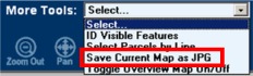 Ā ĀA new browser window will open containing an image of the current active map. You can then right-click on that image for a list of possible actions. Most browsers will at least offer the abilities to: Other actions may appear when you right-click on the image, depending on what software is currently installed on your computer. |